


Since this is a single route leading between two major cities (and major tourist destinations at that), it's pretty straightforward. Accordingly, this Nuts&Bolts section will concentrate on keeping you on the path by pointing out the tricky or unmarked sections. At the very least, it should save you some time.
For photos of the start of the route from Arashiyama, see the Story text. The bikepath begins only a hundred meters or so from Arashiyama Station on the Hankyu train line.
If you want to leave closer to downtown Kyoto, you can also join the bikepath near Katsura Station, also on the Hankyu line. Head straight (east) out of Katsura Station and turn left on Route 142 which leads directly to a bridge (the Katsura Bridge) crossing the Katsura River. The bikepath runs along this bridge and heads south along the far (east) bank.
If you can't get to Hankyu Katsura or are coming by JR, just cycle straight to the Katsura River, which runs diagonally through the southwest part of the city, and look for the bikepath. Unless you're north of the Katsura Bridge mentioned above, it will be on the east bank.
Now let's cover the route itself.
First off: you'll see a lot of these signs along the route:
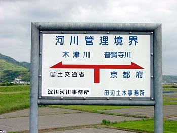
Ignore them. It would be great if these were route markers, but they're not. They're (sigh) your tax dollars at work: signs showing where the bureaucratic river management boundary changes from one government agency to another - in this case, the national Ministry of Land, Infrastructure and Transport (for the section on the left) and the local Kyoto Prefecture public works office on the right. (Ordinary citizens could care less, right?) So the signs will be no help to you and you can ignore them.
Several kilometers after the start of the path, just after you pass under a low bridge, you'll find that the path seems to have disappeared. This is what it looks like when you look back to try to figure out where the path went:
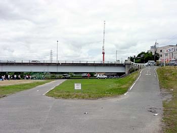
The path actually goes up to the right and then turns back and continues on in the same direction along that upper road (since you're now looking back the way you came, the forward direction is behind you, along the river's left bank). If you choose, you can go along the lower road for awhile, through some rather dusty athletic fields, but eventually you'll have to find a way up to the actual bikepath on the slope to your left.
A bit further on is probably the most confusing point where the bikepath does indeed end right here:
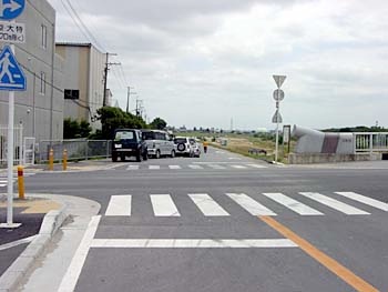
Why on earth isn't there a sign here? It's actually pretty straightforward, if you know you're supposed to turn LEFT here. A block or so further on, you'll see the bikepath resume again.
Around the middle of the long bikepath is a similar location where a simple sign would make all the difference. The path will dead-end at this road:
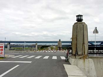
Again, no sign. Off to your right a short distance you should be able to see a rather long bridge over the river, as shown here:
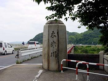
This is the midpoint of the bikepath, where you change from the Katsura River to the Kizu River. The bikepath starts again just past this bridge and travels to the left along the far bank. So when you get to the intersection shown in the previous photo, turn right until you see this bridge, then cross the bridge and turn left when you see the bikepath entrance on the far bank.
That takes us up to the section between the Kyoto and Nara bikepaths. This would also be simple if there were any signs; apparently nobody has thought to combine these two bikepaths before. The important thing is to remember to turn RIGHT on Route 24 when you get to the end of the long bikepath (you'll see the sign for the Kizu River, as shown here in the top photo on this Story page). Turn right and go along the regular road for 2-3 kilometers, until you see the bottom photo on that same Story page. If you look down at the road below and to the left, you'll see the bikepath sign shown below and pointing in the direction of Nara Park (Nara Koen):
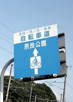
Just follow that sign - you should be in downtown Nara in about 20 minutes to half an hour. The bikepath ends in a rather urbanized area, but there are lots of signs to point you to the park. If you get confused, just ask someone to point you to "Nara Koen."