


Getting There
Both the peninsula and the small city of Yawatahama are located on Shikoku’s west coast between Matsuyama and Uwajima. Both of these are sizable cities, so there’s regular train service to the area. Ferries also come here from Honshu and Kyushu, mainly docking at Matsuyama.
If you’re starting the route from Ozu, you’ll begin by following the signs toward Yawatahama that point you in the direction of Route 220-something, but almost immediately the signs change to indicate that you’re on the main route, Route 197, which you’ll be following all the way to the end of the peninsula. So from this point on, it’s pretty self-explanatory, especially since you’re following the coast around a peninsula.


Accommodations
Since this is such a short route, you probably won’t need accommodations except at your base camp. If you want accommodations nearer to the end of the peninsula, there are a surprising number of places to stay in Misaki (where the bus stop is located), at least according to the following website which bears a 2004 date. Note that in rural non-tourist areas ryokan can often be as inexpensive as minshuku.
http://goske.jp/goske/kankou/misayado.htm
(note: Japanese browsers should be set to shift-JIS text encoding to view properly)
The names and phone numbers given on the page are as follows. The first two are nearer to the end of the peninsula, with the first one described as “Shikoku’s westernmost inn” (it’s almost at the end, when the road turns briefly toward the southern side of the peninsula).
Kanazawa Ryokan (0894) 56-0022
Ryokan (Minshuku) Ouiwa (0894) 56-0070
Ebisuya Ryokan (0894) 54-0013
Yamamoto Ryokan (0894) 54-1455
Tachibana Ryokan (0894) 54-0056
Matsuda Ryokan (0894) 54-0048
Ryokan Sugiyama (0894) 54-0037
Kikuya Ryokan (0894) 54-0125
Lollipop [coffeeshop that supposedly offers no-meals accommodation] (0894) 54-0043
Bike Yado “Walk On” (090) 7575-7829 [supposedly a warehouse converted into an ultracheap crash pad for motorcyclists; opens at 7 p.m.]
Minshuku Hamada (0894) 54-1558
There’s a page showing accommodations for Yawatahama as well:
http://www.city.yawatahama.ehime.jp/mtb/yawatahama/syukuhaku.html
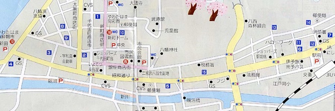
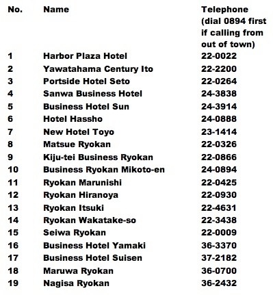
However, it’s a bit difficult to read, so here is a map provided by the city with numbered accommodations (the blue ones) - hopefully they won’t mind the scan. The train station is shown at lower right in the map. The list below the map shows the telephone numbers for each place. Sharp-eyed readers will note that only 15 of the 19 numbers appear in the map; the others are further to the northwest (which is actually a bit nearer to the peninsula if further out from the center of town).
Sights
There’s not really much of tourist interest on this route until the lighthouse at the very end. However, special mention should be made of Ryoshi Monogatari, a large seafood restaurant near the end of the peninsula (near Sadamisaki Harbor); it’s apparently very well-known but quite pricey.
Getting Away
As noted in the Story text, if you’ve taken the northern roads on the way back, you can either cycle back along the main road to Yawatahama or cycle up the coast to Iyo-Nagahama which is the nearest train station accessible from the northern end of the peninsula. Needless to say, if you’re energetic and have the time, you could also cycle all the way up to Matsuyama as well.