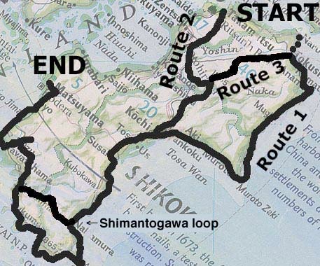

This route assumes that you want to start from the eastern end (where the ferry and bus access from Honshu is) and go counter-clockwise around the island. But of course the routes can be done in reverse as well. The western half is fairly straightforward, since most of the "must see" things are on or relatively near the coast. (The one exception, the Shimanto-gawa River, is indicated by the line in the photo between Nakamura and Uwajima; it could actually be done on a day-trip or overnighter from Uwajima.) However, the eastern end is complicated enough to require three completely separate routes, listed in increasing order of difficulty. Route 1, the coastal route, is by far the easiest one; since it follows the coast, much of it is level, particularly at the bottom. Route 2 is more mountainous, but more scenic, and even the mountains are negotiable (to pun a phrase) to some extent: you can choose to avoid the highest (1,173m) pass if you prefer. Route 3 is a hybrid: it starts from Tokushima but covers the same attractions as Route 2 and goes right by Tsurugi-san, Shikoku's second-highest mountain. However, it also goes over not one but TWO passes above 1,000 meters (1210 and 1,130), so this route is only for people who really like heights. If you have to choose one route, make it Route 2, since it offers two of Shikoku's "must see" attractions: the river gorges of Oboke and Koboke, and the vine bridge(s) of Kazurabashi. Or you could compromise: you could take Route 2 to see the aforementioned spots and then shoot east to the coast, picking up Route 1 before it gets to Muroto Misaki, which is arguably the only "name" attraction on that route. However, if you're dead set against backtracking even a little, you may have to make some choices, which basically boil down to: Route 1, 2 or 3 to start, and then in the west, Shimantogawa River or Cape Ashizuri. For more detailed information, see the Nuts & Bolts section.


