


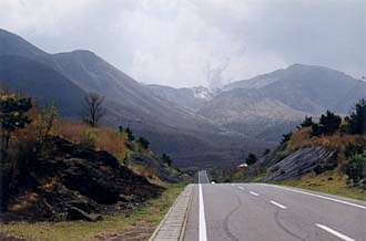


When you see views like this, you know you're headed up into volcano country (if the hot springs hadn't clued you in already). This is the last pass before the lovely Yamanami Highway, one of the many picturesque views from which is shown below. I first discovered this wonderful road on an auto trip with a friend. Stuck in murderous traffic jams trying to get back to the ferry port on a very busy Golden Week vacation one year, we stopped at the Japanese equivalent of a truck-stop diner and got directed here. It was a win-win situation: my friend succeeded in getting his car back to Kansai, and I got a new cycling destination to come to... again and again.
Orientation: the Yamanami cuts diagonally down through nearly half of Kyushu, from Beppu in the northeast almost all the way to Kumamoto in the southwest. Along the way it has great views and access to numerous hot springs towns. It also leads directly to Mt. Aso, one of the main objectives of this trip and my destination for the night.