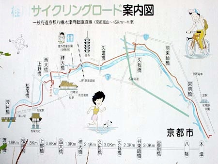


Here's a sign showing the entire route, but in a bit of a disorienting manner: Arashiyama is on the right, and Nara is on the left, and the sign makes it look as if you pass by Kyoto on the east rather than through its western edge At least the name of the bikepath is the official name: the Kyoto-Hachiman-Kizu Jitensha-do, "jitensha" meaning "bicycle" and "do" meaning "route." As the name might indicate, Kizu is the ending point, and Hachiman is the approximate midpoint.
More detailed route maps along the way show the route in greater detail - this section represents only about 1/3 of the total distance of 45 km. Unfortunately, these maps don't appear to be printed and available anywhere. See the Route page for a link to a detailed map in English.
(Here’s the link for your convenience: